Weather 101 for Winter Shore Fishing
Given the recent shore-fishing clinic, we thought it would be a perfect time to talk about two of the factors which can make or break a shore fishing trip: Wind and Ice. Board Members/Instructors Lisa and Aaron discussed wind directions and their effects on fishing at the clinic, so we are going to run through a few graphics that will help you visualize those considerations better.
Winter months into the run-up to the spring runs of kamloops and steelhead offer fantastic opportunities to get out and enjoy the resource, and shore fishing really heats up as more and more fish stage near-shore for spawning. But let's face it, it's still winter. While factors such as air temperature, cloud cover, wave action and water clarity all play a part, wind direction and pack ice can play havoc with any shore fishing outing turning what should have been an enjoyable trip into an exercise in patience and endurance.
Pack ice is certainly more prevalent during winter months, but believe it or not, can hang around well into May. Get the wrong wind and that ice can pile up along the shore making shore fishing difficult if not impossible in a very short period of time.
Below is some Modis satellite imagery from March 2nd, note the almost complete lack of any visible pack ice within the western arm of Lake Superior encompassing the North and South Shore. All of the ice which is there has been pushed tightly up against the South Shore between the westernmost Apostle Islands and the Superior Ship Canal/Entry. It doesn't look like much, but there is a significant amount there, especially out in front of the Nemadji from the State Line over to the mouth of the Brule.
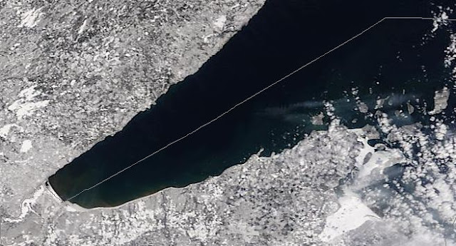
In this next image from March 4th, you see the effects of westerly and southerly winds on that same ice as it is pushed off shore from the western arm all the way over to Chequamegon Bay in just under 48 hours. What looked like no ice has suddenly turned into a significant amount out in the lake. And remember, the smallest objects you can see at this resolution are 800 feet across which tells you it's a heck of a lot of ice. I threw Two Harbors and French River in there just so you get a feel for the geography.

If we get anything like a WSW, SW or South wind, that ice is going to get pushed from its current location right smack into the North Shore and all of the prime shore fishing real estate; and very quickly if it is a strong wind with heavy swell. The practical problem is that even with loose ice, wind and wave action will cause it to compact along the shore. It is dang difficult to fish a bottom line or jig and float, let alone get it through the ice cover to begin with when this happens.
The practical application for all of this is getting a feel for what you might run into. It's simply about making calculated decisions regarding fishing based on available information. There's no substitute for a boots on the ground buddy report, but this will help you plan absent that kind of connection.
Ok, so we know that on the 4th of March, pack ice was sailing merrily along in the general direction of the North Shore, what can we look at next if we are planning a shore fishing trip for the 6th for example? There are a plethora of forecasting tools available; I personally use many but my go-to at the present time is Weather Underground It has a bajillion useful tools and the short-term (0-72 hours) forecasting has been reasonably accurate over time which is good enough.
Back to the proposed trip on the 6th. The graphic below is the 10-Day forecast for Duluth, MN. Looks like a high of 50 with about a 75-80% chance of rain. I'm more concerned with the low of 28 so warm clothes and a rain jacket are in order since we'll be out there early. I also like the overcast and low pressure (black line). Low pressure just seems to be the bomb for any type of hunting/fishing activity. Pressure changes, particularly prolonged high pressure, doesn't seem to make as much difference in stream fishing as it does in lake fishing, presumably due to the nature of moving water, but it's something to think about.

The biggie here is the wind direction (bottom blue line with arrows) on the 6th. SSE to S winds in the forecast which could potentially move that ice in and cause problems given the wind direction on the 5th as well. One of the things I like about the tools available on Wunderground is you can hover over the forecast map with your mouse and get an hour-by-hour breakdown of the conditions as shown below:
 By simply moving your mouse cursor left and right around the forecast, you get an hourly readout of temperature, precipitation chance, pressure, windspeed and direction: Here at 2 p.m. forecasted 48 degrees, 75% chance of rain, 29.28 in pressure and winds of 14 mph from the SE.
Putting this all together: Modis imagery plus forecast, we have enough to make a pretty good decision about a trip. It's too bad the images from the 5th aren't finished yet or we would have a more complete picture. If it was up to me, we would still be planning on fishing at this point, but I'm just not sure what is going to happen with that pack ice. There are enough locations to fish along the shore, so everything I see here tells me that if locations between the Lester and Knife are iced up when we actually get there, it's a good bet based on wind directions between now and the 6th that we'll just need to go a little further north to find an ice-free location. Just don't forget your cleats!
Regards and good fishing!
Minnesota Steelheader
Winter months into the run-up to the spring runs of kamloops and steelhead offer fantastic opportunities to get out and enjoy the resource, and shore fishing really heats up as more and more fish stage near-shore for spawning. But let's face it, it's still winter. While factors such as air temperature, cloud cover, wave action and water clarity all play a part, wind direction and pack ice can play havoc with any shore fishing outing turning what should have been an enjoyable trip into an exercise in patience and endurance.
Pack ice is certainly more prevalent during winter months, but believe it or not, can hang around well into May. Get the wrong wind and that ice can pile up along the shore making shore fishing difficult if not impossible in a very short period of time.
Below is some Modis satellite imagery from March 2nd, note the almost complete lack of any visible pack ice within the western arm of Lake Superior encompassing the North and South Shore. All of the ice which is there has been pushed tightly up against the South Shore between the westernmost Apostle Islands and the Superior Ship Canal/Entry. It doesn't look like much, but there is a significant amount there, especially out in front of the Nemadji from the State Line over to the mouth of the Brule.

In this next image from March 4th, you see the effects of westerly and southerly winds on that same ice as it is pushed off shore from the western arm all the way over to Chequamegon Bay in just under 48 hours. What looked like no ice has suddenly turned into a significant amount out in the lake. And remember, the smallest objects you can see at this resolution are 800 feet across which tells you it's a heck of a lot of ice. I threw Two Harbors and French River in there just so you get a feel for the geography.

If we get anything like a WSW, SW or South wind, that ice is going to get pushed from its current location right smack into the North Shore and all of the prime shore fishing real estate; and very quickly if it is a strong wind with heavy swell. The practical problem is that even with loose ice, wind and wave action will cause it to compact along the shore. It is dang difficult to fish a bottom line or jig and float, let alone get it through the ice cover to begin with when this happens.
The practical application for all of this is getting a feel for what you might run into. It's simply about making calculated decisions regarding fishing based on available information. There's no substitute for a boots on the ground buddy report, but this will help you plan absent that kind of connection.
Ok, so we know that on the 4th of March, pack ice was sailing merrily along in the general direction of the North Shore, what can we look at next if we are planning a shore fishing trip for the 6th for example? There are a plethora of forecasting tools available; I personally use many but my go-to at the present time is Weather Underground It has a bajillion useful tools and the short-term (0-72 hours) forecasting has been reasonably accurate over time which is good enough.
Back to the proposed trip on the 6th. The graphic below is the 10-Day forecast for Duluth, MN. Looks like a high of 50 with about a 75-80% chance of rain. I'm more concerned with the low of 28 so warm clothes and a rain jacket are in order since we'll be out there early. I also like the overcast and low pressure (black line). Low pressure just seems to be the bomb for any type of hunting/fishing activity. Pressure changes, particularly prolonged high pressure, doesn't seem to make as much difference in stream fishing as it does in lake fishing, presumably due to the nature of moving water, but it's something to think about.

The biggie here is the wind direction (bottom blue line with arrows) on the 6th. SSE to S winds in the forecast which could potentially move that ice in and cause problems given the wind direction on the 5th as well. One of the things I like about the tools available on Wunderground is you can hover over the forecast map with your mouse and get an hour-by-hour breakdown of the conditions as shown below:

Putting this all together: Modis imagery plus forecast, we have enough to make a pretty good decision about a trip. It's too bad the images from the 5th aren't finished yet or we would have a more complete picture. If it was up to me, we would still be planning on fishing at this point, but I'm just not sure what is going to happen with that pack ice. There are enough locations to fish along the shore, so everything I see here tells me that if locations between the Lester and Knife are iced up when we actually get there, it's a good bet based on wind directions between now and the 6th that we'll just need to go a little further north to find an ice-free location. Just don't forget your cleats!
Regards and good fishing!
Minnesota Steelheader


Comments