Yeah, We're Wondering Too....

The natural inclination is to want to at least drive by the streams if not jump out and walk them, but when you live more than a casual drive away, what do you do to scratch that persistent if not maniacal itch?
In this age of technological sorcery, there are all kinds of tools available to the steelheader, and all it takes is an internet connection and a browser that will hopefully act as a sort of electronic steelheader's version Gold Bond or Anti Monkey-Butt powder. Let's face it, the itch is ultimately incurable, but there are ways to make it less annoying.
Over the years, we have discovered a number of highly useful tools, and developed methods which allow us to keep tabs on what is happening up and down the North Shore, particularly during the early stages of Spring thaw. Year to year weather variability makes predicting migratory fish runs impossible, but if you understand the cycle, there are some very clear indicators of what is going on which help you dial in steelhead and kamloops activity. For you deer hunters out there, it's a bit like understanding late summer deer patterns, pre-rut, rut, and post-rut signs and activity. Figure those out and you know where and when to hunt; and steelheading isn't all that dissimilar conceptually speaking.
Two of the primary things we begin looking at during the early stages of Spring (or rapid warmup in the case of 2017) are satellite imagery and stream-flows. What we are looking at specifically in both types of tools is driven by the daily cycle of the sun combined with air temperatures and precipitation.
As photo-period increases during Spring due to our annual trek around the sun combined with the way the planet is tilted, we get longer and longer days resulting in more and more warming. This typically results in accelerating snow-pack melting. The unusually warm air temps we are getting right now along with potentially liquid precipitation tends to accelerate melt even further. We've outlined the whole process in detail in other blog posts but suffice to say that right now, we are watching for the first signs that the river ice pack is breaking up and that sediment is being carried out into the big lake.
The first tool we are currently using is MODIS Satellite imagery
This link will take you to a calendar view, clicking on a date will expand the image. If you hover over Lake Superior, you'll notice a blue box appears. Clicking anywhere inside that box will bring up a 2000 meter resolution image for that date. You can get a general idea of the extent of snow and ice cover from the image at this resolution, but to see finer detail of things like brown-up and sediment plumes flowing out into the lake, select 250 meter resolution above the image. You'll have to use your scroll-bars at this point, but you'll be able to see objects as small as 820 feet across in the image; not bad for a martian's eye view from space.
Again what we are looking for here right now is brown-up (snow-melt) along the North Shore and in the St. Louis and Nemadji River valley near the lake. The reason this is important is that we need exposed ground to increase the chances that runoff will be contributing warmer water to the streams rather than just melted snow. Any runoff containing sediment along with the sediment already in the streams begins flowing out into the lake. This sediment carries the unique chemical signatures out into the lake which help the steelhead to navigate back to their home water, and these plumes are what we are looking for in the images. The streams also need to be free of ice cover so that all of that increased daily solar radiation warms stream temperatures as well, and we know from the technical literature and our own Creel Project that the early stages of the actual run are all about the temps.
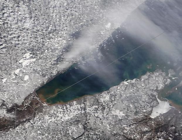
In this image we are looking at conditions from February 18th, 2017. Still a fair amount of snow pack along the North Shore with ice cover in the St. Louis, as well as ice floes along the Wisconsin Coast. There's just a hint of brown-up happening in the St. Louis and Nemadji valley's down closer to the estuary.

Compare that with this image from March 20th, 2016. Brown-up along the North Shore as well as in the St. Louis/Nemadji valley is clearly visible, and a significant sediment plume, primarily from the Nemadji River is plainly evident. There are just hints of plumes coming from streams between the St. Louis all the way up to the Stewart also visible.
The second tool we are looking now at are the various stream packages located along the Lower North Shore. Normally we would be primarily looking at the Knife River USGS Station, but unfortunately there is an ongoing package malfuntion so that one is out for now.
What we are looking for at this stage is probably more important than the where. The Knife is a great early season benchmark station for a couple of reasons, but fortunately given the outage there are others we can use. As for the "what" of what we are looking at, the key primary indicators are derived from gauge height.
As we begin warming in the Spring, the melt-water from snow-pack begins entering the streams. This follows the daily sun-cycle and you start to see a classic heartbeat signature develop in the gauge readings. During the day, melt-water flows into the streams at higher rates, and gauge height increases accordingly. At night as temps dip back down again, the amount of melt-water decreases as things re-freeze, and the gauge drops. Over the course of days or weeks, this regular signature gives you important clues as to when you should begin closely watching the stream temperature readings.
The wild card here are the crazy high temps we are getting now. In any given year where we get these rapid warmups, increased melt-water entering the streams erodes ice more quickly. Less overhead ice cover allows the sun to warm the streams at a more rapid pace. If the snow-pack also rapidly melts down to bare ground combined with warm rains and the ice leaves the streams, things can happen in a hurry.
We're nowhere near that yet, but we are seeing rapid increases in melt-water entering the Lower Shore streams due to this insane heat. Below is a snapshot of one of our Lower Shore Index streams. Note the rapid rise in gauge beginning on the 18th corresponding to the start of the warmup. Prior to that, readings look like a North Shore stream during its typical mid-winter slumber.

During a "normal year", and I use quotation marks because that gets a bit subjective, but if there were such a thing, the normal run-up to pre-run steelheading, the gauge signature we are looking for is illustrated below. What you're seeing here is an ice breakup signature from 2016: lots of ice movement and damming causing the first big spike. The other indicator of good daily melt happening is that heartbeat-like signature developing post-ice dam blowout. Taken together these are telling us the ice is on its way out, and steelheading isn't too far behind.

So far though it is way too early to tell, but we are watching conditions that much more closely. We won't really know much until this warm spell plays itself out. We know we are in for a couple more days of crazy-high temps, it's what happens immediately after that which will begin to give us some more concrete news. Until then we'll keep watching and wondering.
All the best in 2017!
Minnesota Steelheader


Comments
Cheers-
Minnesota Steelheader