Psst hey... wanna see something kinda cool?
In the interest of being a well rounded steelheader, I'm always on the prowl for information sources which can give me a feel for what's going on out there.
One thing I like to do prior to the spring runs is to keep tabs on the progression of snowmelt going on in the various Superior watersheds. But there's another reason I like to look at this type of information.
Migratory fish use all kinds of chemical markers in the water to navigate home, and part of what gives each river a "smell" all it's own are the unique soil compositions within the home watersheds. Sometimes in spring you can be driving along 61 and the water is a clear, sparkling blue (or a dark, angry, roiling green as often as not). Other times all you see for the first hundred yards or so out is a sea of reddish-brown stained water; the result of snowmelt or rain causing the rivers to rise and carry local sediments out into the Big Lake.
However it happens, even if I'm not looking forward to the prospect of fishing the chocolate yeti that day, it puts a smile on my face because this is all part of the process which calls the fish home. Which is all a roundabout way of introducing you to The NOAA MODIS Sattellite.
I was watching the images back around the 14th of March which is about when I first started to notice the "brown up" occurring in the St. Louis River estuary. That and I was looking for changes in the imagery related to ice-out and snowmelt. What I didn't notice at first was the sediment plume just starting to come out of the St. Louis, but primarily the Nemadji River. What follows is a pretty amazing set of images of that sediment plume being ejected out into the Lake (Click thumbnails for larger image - Warning, they are huge):
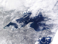


Keep in mind that the smallest feature you can see, (and I'm talking about the smallest dot you can find like one of the ice-floes below the pack-ice off Cornucopia WI there) in something like 900 feet across, which gives you some insight into just how large this plume is.
Couple fun facts for you as to the reasons why the plume is so large- The vast majority of the watershed lies in an area that used to be the bottom of a huge glacial lake. The average yearly sediment load deposited at the mouth of the Nemadji alone is 131,100 tons: 117,000 tons of silt and clay, 14,000 tons of sand. From 1975 to 1994, the Army Corp of Engineers dredged more than 1 million cubic yards of sediment (mostly sand) from Superior bay near the Nemadji River.
Those are some pretty crazy numbers and it affects natural steelhead reproduction in a big way; but more about that another time. I just thought the images, aside from being pretty spectacular, are really just telling the steelhead, "It's time to come home..."
Regards- NMF
One thing I like to do prior to the spring runs is to keep tabs on the progression of snowmelt going on in the various Superior watersheds. But there's another reason I like to look at this type of information.
Migratory fish use all kinds of chemical markers in the water to navigate home, and part of what gives each river a "smell" all it's own are the unique soil compositions within the home watersheds. Sometimes in spring you can be driving along 61 and the water is a clear, sparkling blue (or a dark, angry, roiling green as often as not). Other times all you see for the first hundred yards or so out is a sea of reddish-brown stained water; the result of snowmelt or rain causing the rivers to rise and carry local sediments out into the Big Lake.
However it happens, even if I'm not looking forward to the prospect of fishing the chocolate yeti that day, it puts a smile on my face because this is all part of the process which calls the fish home. Which is all a roundabout way of introducing you to The NOAA MODIS Sattellite.
I was watching the images back around the 14th of March which is about when I first started to notice the "brown up" occurring in the St. Louis River estuary. That and I was looking for changes in the imagery related to ice-out and snowmelt. What I didn't notice at first was the sediment plume just starting to come out of the St. Louis, but primarily the Nemadji River. What follows is a pretty amazing set of images of that sediment plume being ejected out into the Lake (Click thumbnails for larger image - Warning, they are huge):


Keep in mind that the smallest feature you can see, (and I'm talking about the smallest dot you can find like one of the ice-floes below the pack-ice off Cornucopia WI there) in something like 900 feet across, which gives you some insight into just how large this plume is.
Couple fun facts for you as to the reasons why the plume is so large- The vast majority of the watershed lies in an area that used to be the bottom of a huge glacial lake. The average yearly sediment load deposited at the mouth of the Nemadji alone is 131,100 tons: 117,000 tons of silt and clay, 14,000 tons of sand. From 1975 to 1994, the Army Corp of Engineers dredged more than 1 million cubic yards of sediment (mostly sand) from Superior bay near the Nemadji River.
Those are some pretty crazy numbers and it affects natural steelhead reproduction in a big way; but more about that another time. I just thought the images, aside from being pretty spectacular, are really just telling the steelhead, "It's time to come home..."
Regards- NMF


Comments